Piccadilly line
| Colour on map | Dark blue | ||||||||||||||||||||||||||||||||
| Year opened | 1906 | ||||||||||||||||||||||||||||||||
| Line type | Deep Tube | ||||||||||||||||||||||||||||||||
| Rolling stock | 1973 Tube Stock 6 cars per trainset |
||||||||||||||||||||||||||||||||
| Stations served | 53 | ||||||||||||||||||||||||||||||||
| Length | 71 km (44 mi) | ||||||||||||||||||||||||||||||||
| Depots | Cockfosters Northfields |
||||||||||||||||||||||||||||||||
| Journeys made | 176,177,000 (per annum) | ||||||||||||||||||||||||||||||||
|
Rail lines of Transport for London
|
|||||||||||||||||||||||||||||||||
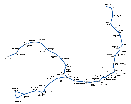
The Piccadilly line is a line of the London Underground, coloured dark blue on the Tube map. It is the fifth busiest line on the Underground network judged by the number of passengers transported per year. It is mainly a deep-level line running from the north to the west of London via Zone 1, with a number of surface sections mostly in its westernmost parts. Out of the 53 stations served, 25 are underground.
Contents |
History
The beginnings
- See Great Northern, Piccadilly and Brompton Railway for detailed histories of the Great Northern, Piccadilly & Brompton Railway (GNP&BR), the Great Northern & Strand Railway (GN&SR), and the Brompton & Piccadilly Circus Railway (B&PCR).
The Piccadilly line began as the Great Northern, Piccadilly & Brompton Railway (GNP&BR), one of several railways controlled by the Underground Electric Railways Company of London (UERL), whose chief director was Charles Tyson Yerkes, although he died before any of his schemes came to fruition.
The GNP&BR was formed from the merger of two earlier, but unbuilt, tube-railway companies taken over in 1901 by Yerkes' consortium: the Great Northern & Strand Railway (GN&SR) and the Brompton & Piccadilly Circus Railway (B&PCR). The GN&SR's and B&PCR's separate routes were linked with an additional section between Piccadilly Circus and Holborn. A section of the Metropolitan District Railway's scheme for a deep-level tube line between South Kensington and Earl's Court was also added in order to complete the route.
When the GNP&BR was formally opened on 15 December 1906, the line ran from the Great Northern Railway's station at Finsbury Park to the District Railway's station at Hammersmith.
On 30 November 1907, the short branch from Holborn to the Strand (later renamed Aldwych) opened, which had been planned as the last section of the GN&SR before the amalgamation with the B&PCR was made. In 1905 (and again in 1965), plans were made to extend it the short distance south under the River Thames to Waterloo, but this never happened. Although built with twin tunnels, single-line shuttling became the norm on the branch from 1918 on, with the eastern tunnel closed to traffic.
Later changes
On 1 July 1910, the GNP&BR and the other UERL-owned tube railways (the Baker Street and Waterloo Railway, the Charing Cross, Euston and Hampstead Railway) were merged, by private Act of Parliament,[1][2] to become the London Electric Railway Company.
On 10 December 1928, a rebuilt Piccadilly Circus station was formally opened. This included a sub-surface booking hall and eleven escalators, replacing the original lifts, and was the start of a considerable renovation of the whole railway, which included a comprehensive programme of station enlargement, on the same basis as the improvements at Piccadilly Circus.
Cockfosters extension

From the 1920s onwards there had been severe congestion at the line's northern terminus, Finsbury Park, where travellers had to change on to trams and buses for destinations in North and North East London. There had been deputations made to Parliament, asking for an early extension of the line either towards Tottenham and Edmonton or towards Wood Green and Palmers Green. The early 1930s was a time of recession, and in order to relieve unemployment Government capital was made available. The chief features of the scheme were an extension northwards from Finsbury Park to Cockfosters. It was also planned to build a station between Manor House and Turnpike Lane at the junction of Green Lanes and St Ann's Road in Harringay, but this was stopped by Frank Pick who felt that the bus and tram service at this point was adequate. However, a 'Ventilation Station', in similar architectural style to tube stations of the time was provided at the site, and is visible today. There was also some opposition from the London and North Eastern Railway to the line. The extension is in tube from Finsbury Park to a point a little south of Arnos Grove. The total length of the extension is 12 km (7.5 mi): it cost £4 million to build and was opened in sections as follows:
- 19 September 1932: to Arnos Grove
- 13 March 1933: to Enfield West (now Oakwood), in conjunction with the westward extension to Hounslow West
- 19 July 1933: completion to Cockfosters
Westward extensions
Powers to link with existing tracks west of Hammersmith were originally obtained in 1913. A Parliamentary report of 1919 recommended through running to Richmond and Ealing. By the end of the 1920s the priority had shifted to serving the areas around Hounslow and north and west of Ealing. The outcome involved taking over the inner pair of tracks between Hammersmith and Acton Town as a non-stop service, while the Metropolitan District Railway would continue to provide the stopping service on the outer pair of tracks.[3] Construction of the linking sections started in 1930, and the services opened as follows.
- to Uxbridge: the District Railway had operated services to Uxbridge since 1910. The District services were taken over by the Piccadilly line:
- 4 July 1932: extended from Hammersmith to South Harrow
- 23 October 1933 (after formation of the London Passenger Transport Board): to Uxbridge
- to Hounslow: the line from Acton Town was quadrupled to Northfields on 18 December 1932 and the Piccadilly line was extended:
- 9 January 1933: to Northfields
- 13 March 1933: to Hounslow West, in conjunction with the eastern extension to Enfield West.
These extensions are notable for the Art Deco architecture of many of their stations, often designed by Charles Holden.
Victoria line
During the planning stages of the Victoria line, a proposal was put forward to transfer Manor House station to the Victoria line, and also to build new "direct" tunnels from Finsbury Park to Turnpike Lane station, thereby cutting the journey time in and out of Central London. This idea was eventually shelved due to the inconvenience to passengers that would have been caused during re-building, as well as the costs of the new tunnels. Even so, the Piccadilly line was still affected at Finsbury Park by the construction of the Victoria line. The westbound service was re-directed through new tunnels, to give cross-platform interchange with the Victoria line on the platforms previously used by the Northern City Line. This work was completed in 1965, and the diversion came into use on 3 October 1965, three years before the opening of the first stage of the Victoria line.
Heathrow extension

In 1975, a new tunnel section was opened to Hatton Cross from Hounslow West. Hounslow West became a tunnel section station. In 1977, the branch was extended to Heathrow Central. This station was renamed Heathrow Terminals 1, 2, 3 in 1984, with the opening of a one-way loop serving Heathrow Terminal 4, to the south of the central terminal area.
During 7 January 2005 until 17 September 2006, the loop via Heathrow Terminal 4 was closed to allow the connection of a spur line to the now operational Heathrow Terminal 5 station. All underground services reverted to two-way working into Terminals 1, 2 and 3, which again became the temporary terminus; shuttle buses served Terminal 4 from the Hatton Cross bus station. For a brief period in the summer of 2006, the line terminated at Hatton Cross and shuttle buses also ran to Terminals 1, 2, 3 while the track configuration and tunnels were altered for the Terminal 5 link from that station. The station at Terminal 5 opened on 27 March 2008 on the same day Terminal 5 opened.
2005 terrorist attack
On 7 July 2005, a Piccadilly line train was attacked by suicide bomber Germaine Lindsay. The blast occurred at 08:50 BST while the train was travelling between King's Cross St. Pancras and Russell Square. It was part of a co-ordinated attack on London's transport network, and was synchronised with three other attacks — two on the Circle line and one on a bus at Tavistock Square. A relatively small high-explosive device, concealed in a rucksack, was used; the bomber died in the explosion.
The Piccadilly line bomb resulted in the largest number of fatalities, with 26 people reported killed. Evacuation proved to be more difficult as it is a deep level line, difficult for the emergency services to reach. The entire line remained closed for the rest of the day. Parts of the line re-opened on 8 July, with no service between Hyde Park Corner and Arnos Grove, and full service was restored on 4 August, exactly four weeks after the bomb.
Infrastructure
Rolling stock

Like virtually all Underground lines, the Piccadilly line is operated by a single type of rolling stock, in this case the 1973 tube stock, in the standard London Underground livery of blue, white and red. Seventy-six trains out of a fleet of 88 are needed to run the line's peak service, and one unit (166-566-366) was severely damaged by the terrorist attack of 7 July 2005. While the stock was recently refurbished, it is due for replacement by 2014.[4]
The line was previously worked by 1959 stock, 1956 stock, 1938 stock, standard tube stock and 1906 gate stock.
The line has two depots, at Northfieldsmap 55 and Cockfosters.map 54 There are sidings at Oakwood, South Harrow, Arnos Grove, Rayners Lane, Down Street, Wood Green, Acton Town, Ruislip and Uxbridge.
Signalling
The line is controlled from the control centre at Earl's Court, which it used to share with the District line. It is in need of resignalling, and this work is planned to be carried out by 2014.
Service pattern
The current service pattern is:
- 6 trains per hour Cockfosters – Heathrow Terminal 5 (via Terminals 1, 2, 3)
- 6 trains per hour Cockfosters – Heathrow Terminal 4 (returning around the loop and serving Terminals 1, 2, 3)
- 3 trains per hour Cockfosters – Uxbridge
- 3 trains per hour Cockfosters – Rayners Lane
- 6 trains per hour Arnos Grove – Northfields
Half of the Uxbridge trains turn back at Rayners Lane: a 10-minute service runs between Acton and Rayners Lane, with a 20-minute service to Uxbridge (this section is supplemented by the Metropolitan line).
Often late evening services terminate at Oakwood instead of Cockfosters.
Trains will also make an additional stop at Turnham Green during early mornings and late evenings but will not stop at the station during the main part of the day.
Other services operate at times, especially at the start and towards the end of the traffic day.
Map
Stations
| Piccadilly line | |||||||||||||||||||||||||||||||||||||||||||||||||||||||||||||||||||||||||||||||||||||||||||||||||||||||||||||||||||||||||||||||||||||||||||||||||||||||||||||||||||||||||||||||||||||||||||||||||||||||||||||||||||||||||||||||||||||||||||||||||||||||||||||||||||||||||||||||||||||||||||||||||||||||||||||||||||||||||||||||||||||||||||||||||||||||||||||||||||||||||||||||||||||||||||||||||||||||||||||||||||||||||||||||||||||||||||||||||||||||||||||||||||||||||||||||||||||||||||||||||||||||||||||||||||||||||||||||||||||||||||||||||||||||||||||||||||||||||||||||||||||||||||||||||||||||||||||||||||||||||||||||||||||||||||||||||||||||||||||||||||||||||||||||||||||||||||||||||||||||||||||||||||||||||
|---|---|---|---|---|---|---|---|---|---|---|---|---|---|---|---|---|---|---|---|---|---|---|---|---|---|---|---|---|---|---|---|---|---|---|---|---|---|---|---|---|---|---|---|---|---|---|---|---|---|---|---|---|---|---|---|---|---|---|---|---|---|---|---|---|---|---|---|---|---|---|---|---|---|---|---|---|---|---|---|---|---|---|---|---|---|---|---|---|---|---|---|---|---|---|---|---|---|---|---|---|---|---|---|---|---|---|---|---|---|---|---|---|---|---|---|---|---|---|---|---|---|---|---|---|---|---|---|---|---|---|---|---|---|---|---|---|---|---|---|---|---|---|---|---|---|---|---|---|---|---|---|---|---|---|---|---|---|---|---|---|---|---|---|---|---|---|---|---|---|---|---|---|---|---|---|---|---|---|---|---|---|---|---|---|---|---|---|---|---|---|---|---|---|---|---|---|---|---|---|---|---|---|---|---|---|---|---|---|---|---|---|---|---|---|---|---|---|---|---|---|---|---|---|---|---|---|---|---|---|---|---|---|---|---|---|---|---|---|---|---|---|---|---|---|---|---|---|---|---|---|---|---|---|---|---|---|---|---|---|---|---|---|---|---|---|---|---|---|---|---|---|---|---|---|---|---|---|---|---|---|---|---|---|---|---|---|---|---|---|---|---|---|---|---|---|---|---|---|---|---|---|---|---|---|---|---|---|---|---|---|---|---|---|---|---|---|---|---|---|---|---|---|---|---|---|---|---|---|---|---|---|---|---|---|---|---|---|---|---|---|---|---|---|---|---|---|---|---|---|---|---|---|---|---|---|---|---|---|---|---|---|---|---|---|---|---|---|---|---|---|---|---|---|---|---|---|---|---|---|---|---|---|---|---|---|---|---|---|---|---|---|---|---|---|---|---|---|---|---|---|---|---|---|---|---|---|---|---|---|---|---|---|---|---|---|---|---|---|---|---|---|---|---|---|---|---|---|---|---|---|---|---|---|---|---|---|---|---|---|---|---|---|---|---|---|---|---|---|---|---|---|---|---|---|---|---|---|---|---|---|---|---|---|---|---|---|---|---|---|---|---|---|---|---|---|---|---|---|---|---|---|---|---|---|---|---|---|---|---|---|---|---|---|---|---|---|---|---|---|---|---|---|---|---|---|---|---|---|---|---|---|---|---|---|---|---|---|---|---|---|---|---|---|---|---|---|---|---|---|---|---|---|---|---|---|---|---|---|---|---|---|---|---|---|---|---|---|---|---|---|---|---|---|---|---|---|---|---|---|---|---|---|---|---|---|---|---|---|---|---|---|---|---|---|---|---|---|---|---|---|---|---|---|---|---|---|---|---|---|---|---|---|---|---|---|---|---|---|---|---|---|---|---|---|---|---|---|---|---|---|---|---|---|---|---|---|---|---|---|---|---|---|---|---|---|---|---|---|---|---|---|---|---|---|---|---|---|---|---|---|---|---|---|---|---|---|---|---|---|---|---|---|---|---|---|---|---|---|---|---|---|---|---|---|---|---|---|---|---|---|---|---|---|---|---|---|---|---|---|---|---|---|---|---|---|---|---|---|---|---|---|---|---|---|---|---|---|
|
|||||||||||||||||||||||||||||||||||||||||||||||||||||||||||||||||||||||||||||||||||||||||||||||||||||||||||||||||||||||||||||||||||||||||||||||||||||||||||||||||||||||||||||||||||||||||||||||||||||||||||||||||||||||||||||||||||||||||||||||||||||||||||||||||||||||||||||||||||||||||||||||||||||||||||||||||||||||||||||||||||||||||||||||||||||||||||||||||||||||||||||||||||||||||||||||||||||||||||||||||||||||||||||||||||||||||||||||||||||||||||||||||||||||||||||||||||||||||||||||||||||||||||||||||||||||||||||||||||||||||||||||||||||||||||||||||||||||||||||||||||||||||||||||||||||||||||||||||||||||||||||||||||||||||||||||||||||||||||||||||||||||||||||||||||||||||||||||||||||||||||||||||||||||||
| Error creating thumbnail: convert: unable to open image `/var/www/mirror/commons_wikimedia_org/images/6/68/Going_to_Covent_Garden\?_notification.png': No such file or directory @ blob.c/OpenBlob/2480. convert: unable to open file `/var/www/mirror/commons_wikimedia_org/images/6/68/Going_to_Covent_Garden\?_notification.png' @ png.c/ReadPNGImage/2917. convert: missing an image filename `/var/www/mirror/commons_wikimedia_org/images/thumb/6/68/Going_to_Covent_Garden?_notification.png/250px-Going_to_Covent_Garden?_notification.png' @ convert.c/ConvertImageCommand/2838. |
(In order from east to west.)
Cockfosters branch
| Cockfosters branch | |||
| Station | Image | Opened | Additional information |
|---|---|---|---|
| Cockfosters | 31 July 1933 | One of the two depots is located heremap 1 | |
| Oakwood |
13 March 1933 | Opened as Enfield West; renamed Enfield WestOakwood 3 May 1934; renamed 1 September 1946map 2 | |
| Southgate | 13 March 1933 | in deep-level tunnelmap 3 | |
| Arnos Grove | 19 September 1932 | Trains may terminate here: there are several sidings for stabling trainsmap 4 | |
| Tunnel section commences | |||
| Bounds Green | 19 September 1932 | map 5 | |
| Wood Green | 19 September 1932 | map 6 | |
| Turnpike Lane | 19 September 1932 | map 7 | |
| Manor House | 19 September 1932 | map 8 | |
| Original Section | |||
| Finsbury Park |
15 December 1906 | map 9 | |
| Arsenal | 15 December 1906 | Opened as Gillespie Road; renamed Arsenal (Highbury Hill) 31 October 1932; the suffix was later dropped in 1960map 10 | |
| Holloway Road | 15 December 1906 | map 11 | |
| Caledonian Road |
15 December 1906 | map 12 | |
| King's Cross St. Pancras |
15 December 1906 | Opened as King's Cross; renamed King's Cross for St. Pancras 1927; renamed 1933map 13 | |
| Russell Square | 15 December 1906 | map 14 | |
| Holborn | 15 December 1906 | Renamed Holborn (Kingsway) 22 May 1933; the suffix was later dropped.map 15 | |
| Covent Garden | 11 April 1907 | map 16 | |
| Leicester Square | 15 December 1906 | map 17 | |
| Piccadilly Circus | 15 December 1906 | map 18 | |
| Green Park | 15 December 1906 | Opened as Dover Street; renamed 18 September 1933map 19 | |
| Hyde Park Corner | 15 December 1906 | In the event of disruption, trains may terminate here via a crossovermap 20 | |
| Knightsbridge | 15 December 1906 | map 21 | |
| South Kensington | 8 January 1907 | map 22 | |
| Gloucester Road | 15 December 1906 | map 23 | |
| Earl's Court |
15 December 1906 | Change for District linemap 24 | |
| Tunnel section ends | |||
| Barons Court | 15 December 1906 | Change for District linemap 25 | |
| Hammersmith |
15 December 1906 | Change for District linemap 26 | |
Extension to Hounslow and Uxbridge
| Extension to Hounslow and Uxbridge | |||
| Station | Image | Opened | Additional information |
|---|---|---|---|
| Turnham Green | 1 January 1869 | Originally the London and South Western Railway; first served by the Piccadilly line 23 June 1963map 27 | |
| Acton Town |
1 July 1879 | Originally the Metropolitan District Railway, later District line; first served by the Piccadilly line 4 July 1932map 28 | |
| The line splits here into two branches — the Heathrow branch and the Uxbridge branch. | |||
Heathrow branch
| Continuing from Acton Town | |||
| Station | Image | Opened | Additional information |
|---|---|---|---|
| South Ealing | 1 May 1883 | Originally the Metropolitan District Railway, later District line; first served by the Piccadilly line 29 April 1935map 29 | |
| Northfields | 16 April 1908 | Originally the District line (one of the two depots is here and some trains terminate here); first served by the Piccadilly line 9 January 1933map 30 | |
| Boston Manor | 1 May 1883 | Originally the District line; first served by the Piccadilly line 13 March 1933map 31 | |
| Osterley | 23 March 1934 | map 32 | |
| Hounslow East |
2 May 1909 | Opened as Hounslow Town by the District line renamed 1 December 1925; first served by the Piccadilly line 13 March 1933map 33 | |
| Hounslow Central | 1 April 1886 | Opened as Heston-Hounslow by the District line, renamed 1 December 1925; first served by the Piccadilly line 13 March 1933map 34 | |
| Tunnel section recommences | |||
| Hounslow West |
21 July 1884 | Opened as Hounslow Barracks) by the District line, renamed 1 December 1925; first served by the Piccadilly line 13 March 1933, resited 19 July 1975map 35 | |
| Hatton Cross | 19 July 1975 | map 36 | |
| Heathrow Terminal 4 |
12 April 1986 | map 37 | |
| Heathrow Terminals 1, 2, 3 |
16 December 1977 | Opened as Heathrow Central; renamed Heathrow Central Terminals 1,2,3 on 3 September 1983; renamed 12 April 1986map 38 | |
| Heathrow Terminal 5 |
27 March 2008 | map 39 | |
|
Just beyond Heathrow Terminals 1, 2, 3 tube station, the line goes into a new section to serve Heathrow Terminal 5 tube station, which opened in March 2008. Half of all Heathrow trains use the loop and serve Terminal 4 and the other half omit Terminal 4 and serve Terminal 5.[5] |
|||
Uxbridge branch
| Continuing from Acton Town | |||
| Station | Image | Opened | Additional information |
|---|---|---|---|
| Ealing Common | 1 July 1879 | Originally the District line; first served by the Piccadilly line 4 July 1932map 40 | |
| North Ealing | 23 June 1903 | Originally the District line; first served by the Piccadilly line 4 July 1932map 41 | |
| Park Royal | 6 July 1931 | Originally the District line; first served by the Piccadilly line 4 July 1932; renamed Park Royal (Hanger Hill) 1 March 1936; renamed 1947map 42 | |
| Alperton | 28 June 1903 | Opened as Perivale-Alperton by the District line; renamed 7 October 1910; first served by the Piccadilly line 4 July 1932map 43 | |
| Sudbury Town |
28 June 1903 | Originally the District line; first served by the Piccadilly line 4 July 1932map 44 | |
| Sudbury Hill ( |
28 June 1903 | Originally the District line; first served by the Piccadilly line 4 July 1932map 45 | |
| South Harrow | 28 June 1903 | Originally the District line; first served by the Piccadilly line 4 July 1932; closed when re-located 4 July 1935; re-opened 5 July 1935map 46 | |
| Rayners Lane | 1 March 1910 | Originally the District line; first served by the Piccadilly line 23 October 1933 (from here to Uxbridge trains share track with Metropolitan line, and some trains terminate here)map 47 | |
| Eastcote | 1 March 1910 | Originally the District line; first served by the Piccadilly line 23 October 1933map 48 | |
| Ruislip Manor | 5 August 1912 | Originally the District line; first served by the Piccadilly line 23 October 1933map 49 | |
| Ruislip | 1 March 1910 | Originally the District line; first served by the Piccadilly line 23 October 1933 (some trains terminate here in Monday-Friday peak hours)map 50 | |
| Ickenham | 1 March 1910 | Originally the District line; first served by the Piccadilly line 23 October 1933map 51 | |
| Hillingdon |
10 December 1923 | Originally the District line; first served by the Piccadilly line 23 October 1933; renamed Hillingdon (Swakeleys) April, 1934; the suffix was later dropped; closed when re-located 5 December 1992; re-opened 6 December 1992map 52 | |
| Uxbridge |
1 March 1910 | Terminus. Originally the District line; first served by the Piccadilly line 23 October 1933; closed when re-located 3 December 1938; re-opened 4 December 1938map 53 | |
Closed stations
.svg.png)
- Aldwych opened on 30 November 1907 as the Strand tube station. It was at the end of a branch line from the main line at Holborn. An evening through-northbound 'Theatre' train ran until 1910. From 1917 onwards, it was served only by a shuttle from Holborn. In the same year it was renamed Aldwych when Charing Cross on the Northern line was renamed Strand. It was temporarily closed in 1940 during World War II to be used as an air-raid shelter. It re-opened in 1946. The possibility of extending the branch to Waterloo was discussed, but the scheme never proceeded.[6] Aldwych was finally closed on 30 September 1994; the level of use was said to be too low to justify the £1 million in estimated costs of a complete replacement of the lifts. The station is regularly used by film makers.
- Brompton Road opened 15 December 1906; closed 30 July 1934, between Knightsbridge and South Kensington.
- Down Street opened 15 December 1906; closed 21 May 1932, between Green Park and Hyde Park Corner.
- Osterley & Spring Grove first served 13 March 1933; closed 24 March 1934 between Boston Manor and Hounslow East. It was replaced by Osterley.
- Park Royal & Twyford Abbey opened 23 June 1903; closed 5 July 1931. Although on the route of the current Piccadilly line, a short distance north of the present Park Royal station, it was never served by Piccadilly line trains. It was opened by the District line, the original operator of the line between Ealing Common and South Harrow, and was closed and replaced by the present Park Royal station before the Piccadilly line started running trains to South Harrow in 1932.
- York Road opened 15 December 1906; closed 19 September 1932, between King's Cross St Pancras and Caledonian Road. It has been suggested[7] that this station may be reopened to serve new developments on the nearby Kings Cross railway lands, although the number of passengers expected to use the station may not be high enough to justify the cost of refitting it to modern standards. The road the station served, 'York Road', has since been renamed 'York Way'.
Future
The Piccadilly line will be upgraded in 2014-15 and will have a stock named 2014 tube stock.
See also
- Leslie Green — architect of the Great Northern, Piccadilly & Brompton Railway's early stations
- Vauxhall Cross tube station — fictional Piccadilly line tube station
Maps
|
|
Sources
- Barker, T. C.; Robbins, Michael (1974). A History of London Transport: Volume two — the Twentieth Century to 1970. George Allen & Unwin Ltd.
References
- ↑ London Gazette: no. 28311, pp. 8816–8818, 1909-11-23. Retrieved 2008-05-27.
- ↑ The merger was carried out by transferring the assets of the CCE&HR and the BS&WR to the GNP&BR and renaming the GNP&BR as the London Electric Railway.
- ↑ Barker & Robbins, p.252
- ↑ "Tube Lines invites expressions of interest from manufacturers for new Piccadilly line trains". Tubelines. 15 January 2007. http://www.tubelines.com/news/releases/200701/20070115.aspx. Retrieved 17 August 2007.
- ↑ "Piccadilly line's new timetable". Transport for London. 8 January 2008. http://www.tfl.gov.uk/corporate/media/newscentre/7156.aspx. Retrieved 16 January 2008.
- ↑ "More Tube Lines Discussed". The Times. 27 April 1965.
- ↑ "York Way Station". Alwaystouchout.com. 11 January 2006. http://www.alwaystouchout.com/project/50. Retrieved 11 July 2008.
External links
- "Piccadilly line facts". Transport for London. http://www.tfl.gov.uk/tfl/corporate/modesoftransport/tube/linefacts/?line=piccadilly. Retrieved 11 July 2008.
- The Piccadilly Line
|
||||||||||||||||||||||||||||||||||||||
|
|||||||||||||||||||||||